

Li a' Tuath [North Lee]
Good walks are even better shared.
Overview
Li a' Tuath [North Lee]
Nestled in the Cork and Kerry Mountains, Li a' Tuath stands proudly at an elevation of 580 meters, making it an enchanting destination for outdoor enthusiasts. As a classified Marilyn, it captures the intrigue of hikers looking to explore its scenic vistas and unique terrain.
Geology
The geological features of Li a' Tuath reflect the dynamic forces of nature. Composed primarily of schist and granite, the rock formations tell a story of glaciation that has shaped these hills. It’s a perfect backdrop for geologists and curious minds alike. Don’t be surprised if you suddenly feel like a rock whisperer!
Routes
The most popular route is the North Lee Approach, spanning approximately 5.2 km. This moderate trail begins at the forest entrance, leading you through lush woodlands before presenting the rocky ascent to the summit. Allow around 3.5 hours for the journey, unless you find yourself distracted by the beauty surrounding you.
Summit Features
Upon reaching the summit, you are greeted by a sizeable cairn. Take a moment to savour the view and strengthen your resolve with a snack. It’s the perfect place to regroup before deciding whether to tackle another peak or start crafting your memoir about today’s adventure.
Terrain Type
The terrain here is a delightful mix of rocky outcrops and grassy slopes, punctuated by occasional boggy patches that will help you test your balance skills. Definitely take care when navigating these areas, lest you be awarded the title of Master of Mud.
Views
From the summit, you are treated to breathtaking panoramic views. You’ll see the Lee Valley unfold below, with the magnificent Macgillycuddy's Reeks peppering the horizon in the distance. Spring and early autumn promise the best vistas—though winter adventures offer their own captivating beauty if you're feeling daring.
Hazards
Hikers should be aware of the variable weather that can turn a sunny stroll into a blustery battle. Loose rocks and slippery trails are also part of the experience, so tread carefully. And remember, if a sheep gives you the side-eye, it’s probably judging your hiking attire!
Nearby Summits
If you’re feeling energetic, consider grabbing your hiking boots and tackling nearby peaks such as Knockbrack Mountain (601 meters) or Carrigtoo (640 meters).
Access
Nearest Parking
You’ll find a small parking area at the forest entrance, accommodating around 10 vehicles. Arriving early will ensure you don’t go chasing wild sheep for parking.
Public Transport
The nearest bus stop is in Ballincollig, around 15 km from the trailhead. Taxis provide the best option for the final leg of your journey.
Nearest Town
Ballincollig is your closest town, perfect for stocking up on supplies or enjoying a post-hike treat.
Facilities
For those needing to refresh after their adventure, Ballincollig offers cafes, restaurants, and public toilets to cater to your needs.
History
The name ‘Li a' Tuath’ has an interesting etymology, directly translating to ‘North Lee’, a nod to its geographical position near the River Lee. Its historical significance cannot be overstated, giving a sense of heritage to your hike.
In conclusion, Li a' Tuath [North Lee] is more than just a hill; it's a rewarding hiking experience marked by striking views, diverse geology, and a welcoming community spirit. Lace up your boots and discover what makes this mountain a cherished gem in the Irish landscape!
Enjoy your adventure and remember—there’s always a peak waiting to be conquered!
Explore routes near Li a' Tuath [North Lee]
Public walks starting within 80 km of this hill. Nearby does not mean a route reaches the summit; check its map and access before setting out.
Berneray Community Hall to the beautiful beach
View route
Dun Mhulan Broch Quick Walk
View route
Beautiful private beach walk Isle of Harris
View route
Route planning notes
These notes describe possible approaches, not verified navigable routes or permission to cross land. Check current paths, local access rules and conditions before setting out.
North Lee Approach
This route begins at the forest entrance and winds through scenic woodlands before ascending the rocky terrain leading to the summit.
Make a day of it, together
Find someone to share the walk with, or organise a day out along a route you like.
Photo Gallery
View all Photo could not load
NF9265 : Li a Tuath (North Lee)
Richard Webb
 Photo could not load
NF9266 : Slopes of North Lee/Li a Tuath
Richard Webb
 Photo could not load
NF9266 : Li a Tuath / North Lee
Richard Webb
Hill facts and local notes
Classifications
Elevation
263m
863 ft
Prominence
175m
Coordinates
57.5794, -7.1432
NF926660
OS Map
18
Explorer: 454E
At the Summit
The summit is adorned with a substantial cairn, offering the perfect place for a well-deserved snack while you contemplate the universe—or at least the next summit.
Terrain & Geology
Li a' Tuath is primarily composed of schist and granite formations. The geological history reflects the dynamic processes of glaciation and erosion, providing a rich tapestry for those interested in Earth's intricate narrative.
Views & Scenery
From the summit, one can witness stunning views of the Lee Valley and the distant peaks of the Macgillycuddy's Reeks. On a clear day, the coastline stretches out like the world's best-kept secret.
History & Heritage
Name Origin
The name 'Li a' Tuath' translates roughly to 'North Lee', referring to its location overlooking the River Lee. It’s a name that has surely seen more mispronunciations than it cares to remember.
Historical Significance
This mountain holds cultural significance for local hiking communities and offers insights into the natural heritage of the region.
Getting There & Facilities
Check current local access restrictions, parking rules and transport timetables before travelling. These notes do not confirm public access to the summit.
Parking
There is a small parking area at the entrance to the nearby forest, accommodating roughly 10 vehicles. Arrive early to secure a spot, particularly during weekends.
Public Transport
The nearest bus stop is in the town of Ballincollig, approximately 15 km away. From there, local taxi services can assist with transportation to the trailhead.
Nearby Facilities
The closest facilities are located in Ballincollig, where you can find cafes, restaurants, and public toilets to refresh yourself after a day of hiking.
Safety Information
Known Hazards
- Variable weather can change abruptly, creating challenging conditions. Be cautious of loose rocks and slippery trails, especially in wet weather. Don't forget to keep an eye out for low-flying sheep!
General Safety Tips
- Check weather conditions before setting out
- Carry appropriate clothing and equipment
- Let someone know your planned route
- Take a map, compass, and GPS device
- Carry emergency supplies: food, water, first aid kit, torch
Hills
Some common questions about the hills answered
Are there group walks up Li a' Tuath [North Lee]?
Many walkers use Walkmates to join or organise walks with others. You can check for group walks around Li a' Tuath [North Lee] through the maps
Are there other walkers around Li a' Tuath [North Lee]?
Activity varies by location and time, but Walkmates lets you see whether others have shared walks or shown interest in this area. Find other people through the walking friends search walking friends for Li a' Tuath [North Lee] search or of course create your own walk for Li a' Tuath [North Lee]
Can I organise a walk to Li a' Tuath [North Lee]?
Yes. If there aren’t any walks listed already, you can create a walk and make it available for others to join.
If you're signed up to Walkmates, you can create a walk to Li a' Tuath [North Lee].
How do I find a walk up this hill?
There are often multiple ways to walk this hill, depending on experience and route preference. Walkmates helps you explore walks and routes that others have shared.
Can I suggest a new route up Li a' Tuath [North Lee]?
Yes. You can suggest or create routes to share with others. Walkmates focuses on the social side of walking, so routes are used to help people organise walks and explore areas together, rather than as detailed navigation tools or route libraries.
Other uses really appreciate knowledgeable walkers sharing their routes. Share your favourite route to Li a' Tuath [North Lee] here
The is an error or something incorrect about this hill. How do I let you know?
We always strive to keep the information on Walkmates as accurate as possible. If you find an error, please let us know through the contact form and we'll aim to correct it as quickly as possible
Community Discussion
Comments
Location
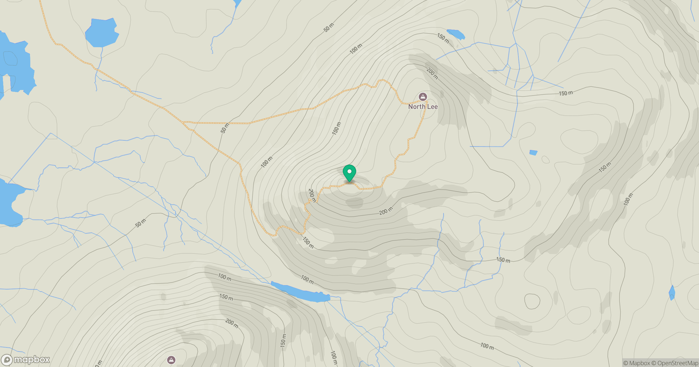
Grid reference: NF926660
View on OpenStreetMapOpens a map in a new tab, centred on the hill.
Hills within 30 km
Straight-line distance, not a walking route or confirmation of access.
Eabhal [Eaval]
347m
Burebhal [Burrival]
147m
Beinn a' Charnain
115m
Beinn Mhor
190m
Crogearraidh Mor [Crogary Mor]
180m
No comments yet. Be the first.